Related Articles


Lahore’s Dangerous Dance: Urban Sprawl Invades Ravi Floodplain, Escalating Flood Risk
The News: A City’s Reckless Expansion
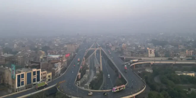
Recent revelations from Pakistan’s Space and Upper Atmosphere Research Commission (Suparco) paint a concerning picture for Lahore, one of Pakistan’s largest and most historically significant cities. A stark comparison of Landsat satellite imagery from 1990 and 2025, made available through Suparco’s ‘Space4Climate’ portal, unequivocally demonstrates a dramatic and rapid urban sprawl into the natural floodplain of the Ravi River. This unchecked development, where brown patches of construction aggressively replace green landscapes and agricultural land, is effectively narrowing the river’s essential corridor, significantly elevating the city’s vulnerability to devastating floods.
Adding a critical layer of geopolitical complexity and heightened danger, the news also highlights that since 2025, India has unilaterally held the 1960 Indus Waters Treaty (IWT) in abeyance, ceasing the crucial sharing of advance flood information and daily river discharge data with Pakistan. This absence of warning further compounds the risks faced by Lahore and other downstream communities along the Ravi, transforming what might be a manageable threat into an unpredictable peril.
Background: The Ravi, Lahore, and a Treaty in Limbo
To fully grasp the gravity of Lahore’s current trajectory, it’s essential to understand the historical and ecological context. Rivers like the Ravi are the lifeblood of regions, shaping landscapes and sustaining civilizations. For millennia, the Ravi has nourished Lahore, providing water for agriculture and acting as a natural drainage system. A river’s floodplain is not merely dry land; it is a dynamic, integral part of the river ecosystem designed to accommodate excess water during monsoon seasons or heavy rainfall events. These areas naturally absorb and convey floodwaters, protecting human settlements further inland.
However, the Ravi’s condition downstream of the Indian border has been uniquely altered by the 1960 Indus Waters Treaty. Under this landmark agreement, the waters of the Eastern Rivers – Ravi, Sutlej, and Beas – were largely allocated for India’s exclusive use. Consequently, the Ravi flowing into Pakistan often appears as a narrow stream or even runs dry for much of the year, only to swell dramatically during monsoon flows or when India releases excess water from its dams.
This historical context is crucial when considering the recent development: India’s unilateral decision in 2025 to suspend the treaty’s data-sharing mechanisms. Historically, Pakistan relied on this data for advance warnings, enabling authorities to prepare for potential floods, manage water resources, and evacuate vulnerable populations. The sudden cessation of this critical information creates an alarming void, making any development within the Ravi’s active floodplain not just risky, but exceedingly precarious. Climate change further exacerbates this, as global warming contributes to more intense and erratic monsoon patterns, increasing both the frequency and severity of flood events.
Impact on Pakistan: A Cascade of Risks
The convergence of unchecked urban expansion and the absence of vital flood data presents a multi-faceted threat to Pakistan, particularly to a major economic and cultural hub like Lahore.
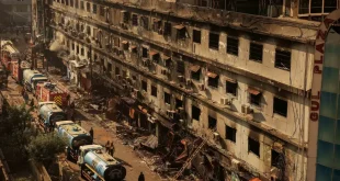
- Direct Flood Catastrophe: The most immediate and terrifying impact is the heightened risk of catastrophic floods. As Suparco warns, with the floodplain narrowed, floodwaters are far more likely to overtop banks, engulfing residential areas, commercial zones, and critical infrastructure. This directly translates to loss of life, displacement of communities, and widespread destruction of property.
- Economic Devastation: The economic fallout from such floods would be immense. Beyond the immediate costs of emergency response and rehabilitation, there would be long-term impacts on livelihoods, agricultural productivity (where floodplains are still used for farming), business continuity, and investor confidence. The rebuilding efforts divert crucial resources that could otherwise be invested in sustainable development.
- Environmental Degradation: Building on floodplains destroys natural habitats, disrupts ecosystems, and compromises the river’s natural hydrological processes. This can lead to reduced groundwater recharge, increased pollution, and a loss of biodiversity, further straining an already vulnerable environment. Environmental lawyer Ahmad Rafay Alam rightly points out that unchecked urbanisation in Lahore is severely impacting its green spaces, which are vital for ecological balance and urban resilience.
- Governance and Planning Crisis: The situation highlights a significant governance challenge. While entities like the Ravi Urban Development Authority (RUDA) claim to incorporate hydrological studies and protective measures, the reality of encroaching settlements and the lack of comprehensive, enforced floodplain zoning indicate a disconnect. The fact that existing floodplain protection laws reportedly do not apply to RUDA-controlled areas creates a dangerous loophole that undermines collective safety and environmental stewardship.
- Exacerbated Geopolitical Vulnerability: The suspension of IWT data-sharing transforms a natural hazard into a complex geopolitical vulnerability. Pakistan’s ability to forecast and mitigate flood events on the Ravi is now severely hampered by a decision external to its control, placing its citizens at the mercy of both natural forces and interstate relations.
Analysis: Balancing Ambition with Ecological Reality
Lahore stands at a critical juncture, where the ambitions of urban development clash directly with the immutable laws of nature and the realities of regional politics. The Suparco findings are not merely satellite images; they are a stark warning of impending disaster if current patterns persist.
The Development Dilemma: RUDA’s Vision vs. Floodplain Ecology
Development authorities like RUDA argue for controlled, engineered solutions, citing hydrological studies and plans for channelization, barrages, and a significant river creek capable of handling high flood flows (up to 600,000 cusecs). While engineering measures can mitigate some risks, they are not a panacea. Channelizing a river fundamentally alters its natural dynamics and can have unintended ecological consequences. Moreover, the effectiveness of such ambitious projects hinges entirely on their flawless execution, continuous maintenance, and, crucially, being based on comprehensive data that fully accounts for extreme and unpredictable events – a task made infinitely harder by the lack of Indian flood data.
The contradiction is glaring: Suparco warns against urban encroachment and recommends strict zoning, while RUDA plans extensive development within what was historically the river’s active floodplain. The claim that no approved housing schemes are in the floodplain, coupled with admissions of demolishing inundated homes and directing other societies to build embankments, suggests a reactive rather than a proactive approach. It also highlights the widespread issue of non-compliance and potentially weak enforcement of regulations, even within regulated zones.
As Prof. Dr. Noor Muhammad of UET Lahore suggests, successful floodplain development, like in London or Paris, is underpinned by “detailed hydrological studies and planning frameworks” – not just physical infrastructure. This implies a long-term, integrated vision that prioritizes safety and sustainability over rapid construction.
The Perilous Information Vacuum
The unilateral abeyance of flood data sharing by India since 2025 is a game-changer. It represents not just a technical challenge but a profound breach of a treaty mechanism designed to prevent human catastrophe. Without this data, Pakistan is essentially flying blind. Any hydrological models developed by RUDA or other agencies are rendered less reliable without real-time, upstream information, making accurate flood forecasting and timely disaster response nearly impossible. This dramatically elevates the risk for every resident living near the Ravi, regardless of how robust local infrastructure claims to be.
Rethinking Resilience: A Path Forward
To avert an impending crisis, Lahore and Pakistan need a paradigm shift in urban planning and disaster risk management:
- Integrated Urban and Environmental Planning: Development plans must be holistic, respecting ecological boundaries, and prioritizing environmental sustainability alongside economic growth. This means genuine, independent Environmental Impact Assessments (EIAs) and robust master plans that account for climate change realities.
- Strict Floodplain Zoning and Enforcement: There must be unambiguous, legally enforceable floodplain zoning regulations that apply uniformly to all development authorities, including RUDA. Crucially, these regulations must be rigorously enforced, with severe penalties for non-compliance.
- Investment in Internal Early Warning Systems: Given the unreliability of external data, Pakistan must urgently invest in its own advanced flood monitoring and early warning systems, utilizing domestic satellite capabilities and ground sensors to predict and track flood events within its borders.
- Transparency and Accountability: Development authorities must operate with greater transparency, making their hydrological studies, flood risk assessments, and compliance records publicly accessible. Accountability mechanisms are essential to ensure public safety is prioritized over developer interests.
- Diplomatic Re-engagement on IWT: While challenging, Pakistan must continue diplomatic efforts to reinstate the data-sharing provisions of the Indus Waters Treaty, emphasizing the humanitarian imperative of such cooperation.
- Public Awareness and Community Preparedness: Empowering communities with information about flood risks and evacuation procedures is vital for building resilience from the ground up.
Lahore’s beautiful riverfront is not a blank canvas for unbridled development but a vital, dynamic natural system. The choice now is clear: either heed the warnings from Suparco and experts, learning from past mistakes and global best practices, or continue down a path of increasing vulnerability, risking a future defined by preventable tragedy. The safety and sustainability of millions depend on this choice.